




6. L2b Products Format Specification#
6.1 Main Product header#
The Main Product Header (MPH) is an XML file present in all the BIOMASS L2 products.
BIOMASS L2 products are folder based and the MPH is top level leaf of the product tree.
The MPH main scope is to provide all the information related to the:
Genesis of the product;
Identification of the product for example for cataloguing purposes;
Product consistency (filesize).
For the detailed description of the MPH content and format refer to [AD3]. It is very similar to the one described in 4.1, without following fields, which are not present in L2b:
eop:
swathIdentifierSwath identifiereop:
orbitDirectionOrbit directioneop:
wrsLongitudeGridTrack numbereop:
wrsLatitudeGridFrame numbersar:
antennaLookDirectionSAR antenna look direction
6.2 Measurement data sets (MDS)#
The MDS of the L2b products is constituted by the same quantities of L2a, together with the BPS_FNF and Heat Map annotations:
the biophysical measurement consisting of the Forest Height image binary raster layer, representing Top Canopy Height (TCH);
a layer of quality indication, consisting of a percentage value for each of the Forest Height image pixel;
BPS_FNF: this is the Forest mask which defines, for each geographical pixel, the presence or absence of forest and which is used to discard invalid forest regions during aggregation of L2a in L2b products.
If the L2b FD product is provided as input, this MDS is the CFM pre-computed contained in L2b FD product, otherwise it is the FNF from L2a annotation LUT.
a Heat Map of floating point values (float32) which stores, pixel wise, the weight sum that has been used to compute each L2b pixel (this information is completed with the list of all L1c images used by the processor, see input information DSR 6.3.1.3).
Acquisition ID Image: a multilayer image (COG format) where each contributing L2a input incidence map is stored (as a binary map); the number of layers is equal to the number of L2a inputs and their order is the same with respect to the L2a inputs (Tab.42).
For all L2b images, following considerations are the same.
All the L2b images are geocoded to specific BIOMASS tiling latitude-longitude geographic DGG, described in [RD9], ensuring a ground sampling always better than the resolution.
In particular we have that L2b images are aggregations of the L2a products insisting on the same location on ground (a single tile of the above DGG); a different number of L2a products may be available for the MDS geographic grid tile, based on tile dimensions and swath coverage.
The format used to store the L2b images is again the Cloud Optimized GeoTIFF (COG) [RD1].
Details about COG format and its usage to store images are already explained in sec. 4.2 for L2a products and apply as well to L2b products;
Metadata
Metadata is the same of the L2a one, already described in sec. 4.2 and Tab.2, the only difference is the absence of “Swath” metadata in L2b.
Overviews
Same considerations already explained in 4.2
6.3 Annotation data sets (ADS)#
6.3.1 Main ADS#
This section describes in details the content of main ADS for L2b products. Differences from L2b are in the description, where needed.
An overview is provided by the two figures below and by the table which describes all the elements, both for L2b.
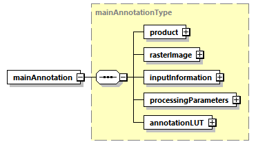
Fig. 19 — main L2b ADS
Table 39 — Main L2b ADS
Name |
Description |
Data Type |
Cardinality |
|---|---|---|---|
product |
Product L2b DSR. This DSR contains the L2b product information. |
|
1 |
|
Raster image DSR. This DSR contains all the necessary information to exploit the L2b raster images. |
|
1 |
InputInformation |
Input Information L2b DSR. This DSR contains the necessary information to identify the L2a products in input to L2b processor and also a list of all the L1c acquisitions used to generate those L2a products. |
InputInformationL2bL3ListType |
1 |
|
Processing parameters DSR. This DSR contains the description of L2b processing parameters. |
|
1 |
annotationLUT |
Annotation LUT DSR. This DSR contains the list of Look-Up Tables (LUTs) complementing product main annotations. |
|
1 |
6.3.1.1 Product L2b DSR#
This DSR contains the parameters to describe the L2b product.
An overview is provided by figures and table below.
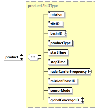
Fig. 20 — product L2b DSR
Table 40 — Product L2b DSR (productL2bType and productType)
Name |
Description |
Data Type |
Cardinality |
|---|---|---|---|
mission |
Mission (BIOMASS). |
|
1 |
tileID |
DGG geographic cell (tile) identifier (one element list). |
|
1 |
basinID |
List of DGG basin identifiers. |
|
1 |
|
Product type ( |
|
1 |
|
Start time of the image [UTC]. |
|
1 |
|
Stop time of the image [UTC]. |
|
1 |
|
Radar carrier frequency [Hz]. |
|
1 |
|
Mission phase identifier. |
|
1 |
|
Sensor mode (always Measurement). |
|
1 |
|
Global coverage identifier. |
|
1 |
6.3.1.2 Raster Image L2b DSR#
This DSR contains all the necessary information to exploit the raster images of all the L2b MDS, it is already described in Fig. 4, Tab.8, Tab.9, Tab.10, Tab.11 with the differences are:
6.3.1.3 Input Information L2b DSR#
This DSR contains, for each of the L2a Product in input to L2b processor:
the folder name of L2a product;
the L1c acquisitions used to generate that L2a product; it is an InputInformationL2aType, see description in 4.3.1.3 and Tab.12, Tab.13, Tab.18.
An overview is provided by figure below and in the table below for the L2inputs.
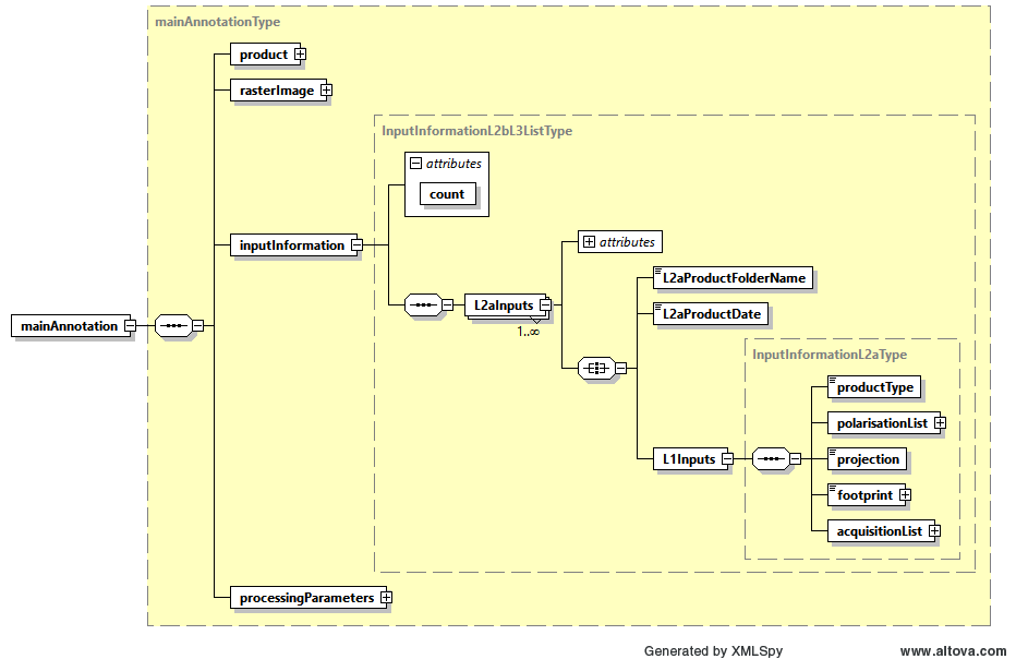
Fig. 21 — Input information L2b DSR (InputInformationL2bL3ListType )
Table 41 — Input information L2b DSR (InputInformationL2bL3ListType )
Name |
Description |
Data Type |
Cardinality |
|---|---|---|---|
count |
XML attribute. |
|
required |
L2aInputs |
One entry for each L2a product in input to L2b. Each entry contains two elements: L2aProductFolderName and L1inputs. |
L2aInputsType |
1…N |
Table 42 — Input information L2b DSR (L2InputsType)
Name |
Description |
Data Type |
Cardinality |
|---|---|---|---|
L2aProductFolderName |
Folder name of each L2a product, as defined in sec. 3.2 (One string for each “L2aInputs” entry). |
|
1 |
L2aProductDate |
Product date for each L2a product |
|
1 |
L1inputs |
L1c acquisitions used to generate the L2a product. See 4.3.1.3 and Tab.12, Tab.13, Tab.18. (One element for each “L2aInputs” entry). |
InputInformationL2aType |
1 |
6.3.1.4 Processing parameters L2b DSR#
This DSR contains the list of L2b processing parameters applied. An overview is provided by figures and table below.
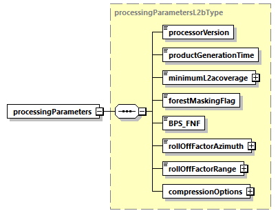
Fig. 22 — processing parameters L2b DSR (processingParametersL2bType)
Table 43 — Processing parameters L2b DSR (processingParametersL2bType)
Name |
Description |
Data Type |
Cardinality |
|---|---|---|---|
|
Version of the processor used to generate the product. |
|
1 |
|
Product generation time [UTC]. |
|
1 |
|
Type of Forest Mask in the Biomass L2b product, it can be the CFM or FNF: CFM if L2b FD product is provided in input, FNF from L2a annotation LUT otherwise. |
bps_fnfType |
1 |
|
The minimum percentage of tile coverage used to trigger the computation. |
|
1 |
|
The minimum percentage of tile coverage used to trigger the computation. |
bool |
1 |
|
True if forest/non-forest map masking has been performed during L2a products merging, false otherwise. |
|
1 |
|
Feathering roll-off factor used. |
|
1 |
|
Configurable compression options for all the L2b MDS COG. |
|
1 |
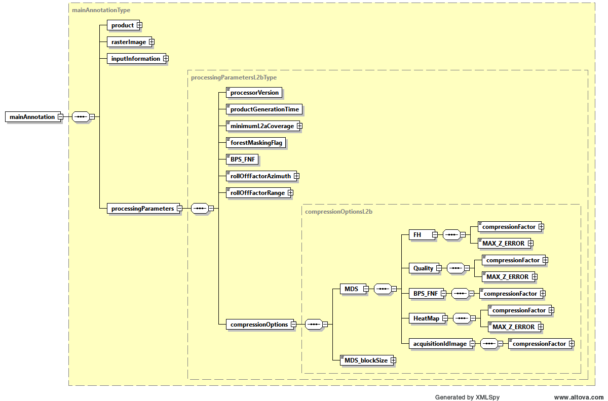
Fig. 23 — Processing parameters L2b DSR (compressionOptionsL2bType)
Table 44 — Processing parameters L2b DSR (compressionOptionsL2bType)
Name |
Description |
Data Type |
Cardinality |
|---|---|---|---|
MDS à FH à |
ZSTD algorithm compression factor for the images MDS. From 0 to 9, where 0 means no compression. |
|
1 |
MDS à FH à |
For the FH, Quality and Heat Map images MDS, define exactly how lossy the LERC compression algorithm is allowed to be, specifying the absolute maximum error admitted. Zero means loss-less compression. |
|
1 |
|
MDS COG blocking algorithm size. Same value is used for both data array dimensions. |
|
1 |
6.3.1.5 Annotation LUT DSR#
This has no difference respect to the one already described in 4.3.1.5.
6.3.2 Quick-look ADS#
The Quick-look ADS is composed by lower resolution versions of all the MDS images (Forest Height, quality layer, forest / non-forest mask, Heat Map).
The details about Quick-look ADS already explained in sec. 4.3.3 for L2a products apply as well to L2b products.
6.3.3 Overlay ADS#
The Overlay ADS is a Keyhole Markup Language (KML) file that describes the product coverage area and is suitable for viewing the Quick-look ADS in any application that supports KML format (like, e.g., Google Earth or GIS applications).
The details about Quick-look ADS already explained in sec. 4.3.4 for L2a products apply as well to L2b products.